多峇(Toba in Indonesia)巨災理論

[編輯首段]維基百科,自由的百科全書

跳转到: 导航, 搜尋
阿拉斯加火山爆發
 
阿拉斯加火山爆發

根據多峇巨災理論,現代人的進化是受到近期一次在印尼多峇湖(Lake Toba)的大型火山爆發造成的巨災所影響。這個理論由美國伊理諾大學(University of Illinios at Urbana-Champaign) 的史坦尼·安布魯士(Stanley Ambrose) 最先提出。

目錄

[隱藏]

[編輯] 理論

人類在最近三至五百萬年與其他靈長類動物在進化中分離。人類之中產生了數種不同的物種。

根據這理論,一次大規模的火山爆發使人類數目大為減少。這火山爆發可能在七至七萬五千年前在印尼多峇湖發生,強度為火山爆發指數的8級,即超大規模(mega-colossal)級數。釋放的能量達到十億噸列性炸藥當量,或為1980年聖海倫火山爆發的三千倍。大量的火山灰令全球溫度在之後數年間下降了攝氏3至3.5度,引起一次冰河時期。

突然的巨大環境改變可能令當時各種物種進入群體樽頸(Population bottleneck),導致分散的人類群體加速異化,最終使現化人的先祖以外的人類絕種。

[編輯] 地理證據

一些地理證據及電腦模擬支持多峇巨災的可能性。基因遺傳證明現在的人類雖然表面看來分別頗大,但根據遺傳基因突變的平均速率推算,現代人全都是源自一個在多峇巨災發生的年代只有一千至一萬人的群體。

[編輯] 遷移

按這理論,巨災之後一段時間,氣候及環境好轉,現代人的祖先從非洲出發,先到達印支半島及澳洲,然後再往中東雙子河流域,及亞洲其他各地。

[編輯] 外部連結

取自"http://zh.wikipedia.org/w/index.php?title=%E5%A4%9A%E5%B3%87%E5%B7%A8%E7%81%BD%E7%90%86%E8%AB%96&variant=zh-tw"

Toba catastrophe theory

From Wikipedia, the free encyclopedia

Jump to: navigation, search

According to the Toba catastrophe theory, 70,000 to 75,000 years ago a supervolcanic event at Lake Toba, on Sumatra, reduced the world's human population to 10,000 or even a mere 1,000 breeding pairs, creating a bottleneck in human evolution. The theory was proposed in 1998 by Stanley H. Ambrose of the University of Illinois at Urbana-Champaign.[1][2]

Contents

[hide]

[edit] History

Within the last three to five million years, after human and other ape lineages diverged from the hominid stem-line, the human line produced a variety of species.

According to the Toba catastrophe theory, a massive volcanic eruption severely reduced the human population. This may have occurred around 70–75,000 years ago when the Toba caldera in Indonesia underwent an eruption of category 8 (or "mega-colossal") on the Volcanic Explosivity Index. This released energy equivalent to about one gigaton of TNT, which is three thousand times greater than the 1980 eruption of Mount St. Helens. According to Ambrose, this reduced the average global temperature by 5 degrees Celsius for several years and may have triggered an ice age.

Ambrose postulates that this massive environmental change created population bottlenecks in the various species that existed at the time; this in turn accelerated differentiation of the isolated human populations, eventually leading to the extinction of all the other human species except for the two branches that became Neanderthals and modern humans.

[edit] Evidence

Some geological evidence and computed models support the plausibility of the Toba catastrophe theory, and genetic evidence suggests that all humans alive today, despite their apparent variety, are descended from a very small population, perhaps between 1,000 and 10,000 breeding pairs.[3][4]

Using the average rates of genetic mutation, some geneticists have estimated that this population lived at a time coinciding with the Toba event. These estimates do not contradict the consensus estimates that Y-chromosomal Adam lived some 60,000 years ago, and that Mitochondrial Eve is estimated to have lived 140,000 years ago, since Toba is not conjectured to be an extremal bottleneck event, where the population was reduced to one breeding pair.

Gene analysis of some genes shows divergence anywhere from 2 million to 60,000 years ago, but this does not contradict the Toba theory, again since Toba is not conjectured to be an extremal bottleneck event. The complete picture of gene lineages (including present-day levels of human genetic variation) allows the theory of a Toba-induced human population bottleneck.[5]

[edit] Migration

According to this theory, humans once again fanned out from Africa after Toba when the climate and other factors permitted. They migrated first to Arabia and India and onwards to Indochina and Australia (Ambrose, 1998, p. 631), and later to the Middle East and what would become the Fertile Crescent following the end of the Würm glaciation period (70,000–10,000 years bp).

[edit] See also

[edit] References

  1. ^ Stanley H. Ambrose (1998). "Late Pleistocene human population bottlenecks, volcanic winter, and differentiation of modern humans". Journal of Human Evolution 34 (6): 623–651. doi:10.1006/jhev.1998.0219. 
  2. ^ Ambrose, Stanley H. (2005). Volcanic Winter, and Differentiation of Modern Humans. Bradshaw Foundation. Retrieved on 2006-04-08.
  3. ^ When humans faced extinction. BBC (2003-06-09). Retrieved on 2007-01-05.
  4. ^ Late Pleistocene human population bottlenecks, volcanic winter, and differentiation of modern humans by Stanley H. Ambrose
  5. ^ Dawkins, Richard (2004). "The Grasshopper's Tale", The Ancestor's Tale, A Pilgrimage to the Dawn of Life. Boston: Houghton Mifflin Company, 416. ISBN 0-618-00583-8. 

[edit] External links

Lake Toba

From Wikipedia, the free encyclopedia

Jump to: navigation, search
Lake Toba
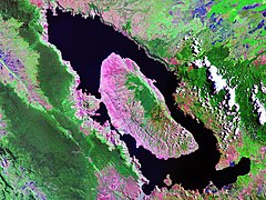
Lake Toba - Landsat photo
Landsat photo
Location North Sumatra, Indonesia
Coordinates 2°37′N, 98°49′E
Lake type Volcanic/ tectonic
Primary outflows Asahan River
Basin countries Indonesia
Max length 100 km
Max width 30 km
Surface area 1,130 km²
Max depth 505 m[1]
Water volume 240 km³
Surface elevation 905 m
Islands Samosir

Lake Toba (Indonesian: Danau Toba) is a lake, 100 km long and 30 km wide, and 505 m. (1,666 ft.) at its deepest point, in the middle of the northern part of the Indonesian island of Sumatra with a surface elevation of about 900 m (3,000 feet), stretching from 2.88° N 98.52° E to 2.35° N 99.1° E. It is the largest volcanic火山的,猛烈的火山岩 lake in the world.[citation needed]

Contents

[hide]

[edit] Geology

In 1949 the Dutch geologist Rein van Bemmelen reported that Lake Toba was surrounded by a layer of ignimbrite熔結凝灰岩 rocks, and that it was a large volcanic caldera 噴火山口. Later researchers found rhyolite [地]流紋岩火山岩之一種ash similar to that in the ignimbrite around Toba (now called Young Toba Tuff 凝灰岩to distinguish it from layers deposited in previous explosions) in Malaysia and India, 3,000 km away. Oceanographers discovered Toba ash, with its characteristic chemical "fingerprint", on the floor of the eastern Indian Ocean and the Bay of Bengal 孟加拉.

[edit] The eruption爆發,火山灰,出疹

Location of Lake Toba shown in red on map.
 
Location of Lake Toba shown in red on map.

The Toba eruption (the Toba event) occurred at what is now Lake Toba about 67,500 to 75,500 years ago. It had an estimated Volcanic Explosivity Index of 8 (described as "mega-colossal巨大的, 龐大的"), making it possibly the largest explosive volcanic eruption within the last twenty-five million years. Bill Rose and Craig Chesner of Michigan Technological University deduced that the total amount of erupted material was about 2800 cubic km (670 cubic miles) — around 2,000 km³ of ignimbrite that flowed over the ground and around 800 km³ that fell as ash, with the wind blowing most of it to the west. By contrast, the 1980 eruption of Mount St. Helens ejected around 1.2 cubic km of material, whilst the largest volcanic eruption in historic times, at Mount Tambora in 1815, emitted the equivalent of around 100 cubic kilometres of dense rock and created the "Year Without a Summer" as far away as North America.

The Toba eruption was the latest of a series of at least three caldera-forming eruptions which have occurred at the volcano. Earlier calderas were formed around 700,000 and 840,000 years ago.[2]

To give an idea of its magnitude大小, 數量, 巨大, 廣大, 量級, consider that although the eruption took place in Indonesia, it deposited an ash layer approximately 15 cm (6 in) thick over the entire Indian subcontinent; at one site in central India, the Toba ash layer today is up to 6 m (20 feet) thick[3] and parts of Malaysia were covered with 9 m of ashfall.[4] In addition it has been calculated that 1010 metric tons of sulphuric acid was ejected into the atmosphere by the event, causing acid rain fallout.[5]

Landsat photo of Sumatra surrounding Lake Toba
 
Landsat photo of Sumatra surrounding Lake Toba

The subsequent collapse倒塌,崩潰,瓦解formed a caldera that, after filling with water, created Lake Toba. The island in the center of the lake is formed by a resurgent dome 復生的,復活的復生的人,復活者-圓頂 加圓頂 成圓頂狀.

Though the year can never be precisely determined, the season can: only the summer monsoon 季節風,吹季節風的季節,雨季 could have deposited Toba ashfall in the South China Sea, implying that the eruption took place sometime during the northern summer.[6] The eruption lasted perhaps two weeks, but the ensuing隨后的,下一個 "volcanic winter" resulted in a decrease in average global temperatures by 3 to 3.5 degrees Celsius for several years. Greenland ice cores 冰核record a pulse of starkly僵硬的,完全的,刻板的,明顯的,荒涼的,結實的 reduced levels of organic carbon sequestration假扣押;退隱. Very few plants or animals in southeast Asia would have survived, and it is possible that the eruption caused a planet-wide die-off. There is some evidence, based on mitochondrial DNA , 線粒體的that the human race may have passed through a genetic bottleneck within this timeframe框架,結構,體格, reducing genetic diversity差異,多樣性 below what would be expected from the age of the species. According to the Toba catastrophe theory proposed by Stanley H. Ambrose of the University of Illinois at Urbana-Champaign in 1998, human populations may have been reduced to only a few tens of thousands of individuals by the Toba eruption.

[edit] More recent activity

Children playing in Lake Toba
 
Children playing in Lake Toba

Smaller eruptions have occurred at Toba since. The small cone of Pusukbukit has formed on the southwestern margin of the caldera and lava 熔岩,火山岩domes圓頂. The most recent eruption may have been at Tandukbenua on the northwestern caldera edge, since the present lack of vegetation could be due to an eruption within the last few hundred years.[7]

Some parts of the caldera have experienced uplift due to partial refilling of the magma chamber [地質]岩漿房, for example pushing Samosir Island and the Uluan Peninsula above the surface of the lake. The lake sediments on Samosir Island show that it has been uplifted by at least 450 metres[8] since the cataclysmic洪水的;大變動的 eruption. Such uplifts are common in very large calderas, apparently due to the upward pressure of unerupted magma. Toba is probably the largest resurgent caldera on Earth. Large earthquakes have occurred in the vicinity 接近,鄰近,附近地區,近處of the volcano more recently, notably in 1987 along the southern shore of the lake at a depth of 11 km.[9] Other earthquakes have occurred in the area in 1892, 1916, and 1920-1922.[10]

Lake Toba lies near a fault line which runs along the centre of Sumatra called the Sumatra Fracture Zone斷裂帶.[11] The volcanoes火山 of Sumatra and Java are part of the Sunda Arc, a result of the northeasterly movement of the Indo-Australian Plate which is sliding under the eastward-moving Eurasian Plate. The subduction zone 俯衝帶in this area is very active: the seabed near the west coast of Sumatra has had several major earthquakes since 1995, including the 9.3 2004 Indian Ocean Earthquake and the 8.7 2005 Sumatra earthquake, the epicenters 震中,中心of which were around 300 km from Toba.

On September 12th, 2007, a magnitude 8.4 Earthquake shook the ground by Sumatra and was felt in the Indonesian capital, Jakarta. The epicenter for this earthquake was not as close as the previous two earthquakes, but it was in the same vicinity.

[edit] People

Toba House
 
Toba House

Most of the people who live around Lake Toba are ethnically人種的;民族的;種族的 Bataks. Traditional Batak houses are noted for their distinctive roofs (which curve upwards at each end, as a boat's hull does) and their colorful decor.

[edit] See also

[edit] References

  1. ^ Worldlakes.org
  2. ^ http://volcano.und.nodak.edu/vwdocs/volc_images/southeast_asia/indonesia/toba.html
  3. ^ Acharyya S.K., and Basu P.K. 1992. "Toba ash on the Indian subcontinent and its implications for correlation of late pleistocene alluvium." Quaternary Research 40:10-19
  4. ^ Scrivenor, J.B. 1931. The Geology of Malaya (London: MacMillan), noted by Weber.
  5. ^ Huang C.Y., Zhao M.X., Wang C.C., and Wei G.J. 2001. "Cooling of the South China Sea by the Toba eruption and correlation with other climate proxies ca. 71,000 years ago." Geophysical Research Letters 28:3915-3918, noted by Weber.
  6. ^ Bühring C., and Sarnthein M. 2000. "Toba ash layers in the South China Sea: evidence of contrasting wind directions during eruption ca. 74 ka." Geology 28:275-278.
  7. ^ http://www.volcanodiscovery.com/volcano-tours/volcanoes/indonesia/sumatra/toba/
  8. ^ http://volcano.und.nodak.edu/vwdocs/volc_images/southeast_asia/indonesia/toba.html
  9. ^ http://earthquake.usgs.gov/eqcenter/eqarchives/significant/sig_1987.php
  10. ^ http://volcano.und.nodak.edu/vwdocs/volc_images/southeast_asia/indonesia/toba.html
  11. ^ http://volcano.und.nodak.edu/vwdocs/volc_images/southeast_asia/indonesia/toba.html

[edit] External links

Indonesia Portal
Retrieved from "http://en.wikipedia.org/wiki/Lake_Toba"
人类起源与进化系列: 人类起源 泥河湾与三星堆遗址 华夏和周边民族史

巴中网站
http://www.boanson.net